Pioneer is at it again. She anchors for the night off Bird Rock, False Pass.
https://www.geonames.org/5857475/bird-rock.html
Alaskan Place Names -- Discussion
Moderator: Matteo
-
studentforever
- Posts: 682
- Joined: Sun Jul 05, 2020 9:23 am
-
studentforever
- Posts: 682
- Joined: Sun Jul 05, 2020 9:23 am
Re: Alaskan Place Names -- Discussion
"Pioneer" is working her way round the False Pass area and puts a party ashore to 'occupy' 2 triangulation stations. One is "Huf" the other has been written as "Can" on right hand page but on left hand page "Can" has been scored out and replaced by "Hit".
The shore parties returned to the ship when she was anchored in King Cove after nosing around Belkofski Bay.
I have put a note on the right hand page transcription but it would be nice to know for certain that "Hit" is the correct name. Could I ask for your help yet again. Thanks.
https://catalog.archives.gov/id/247055403?objectPage=17


-
studentforever
- Posts: 682
- Joined: Sun Jul 05, 2020 9:23 am
Re: Alaskan Place Names -- Discussion
Great. They are pretty close but I suspect that travelling between them could have been a bit strenuous. At least this section of the log only has a month or two more before Pioneer sets off for winter quarters so you may not have too many more additions for the databases. Not sure what Caro will have in mind for the next installment but you won't have to worry about that for a while, there are quite a few highlights to sort out. Thanks again.
Re: Alaskan Place Names -- Discussion
You're most welcome! Glad I could help 
Yep going back and forth to them with motor launches should have been quite a job... and many of them were up hills or however higher than the sea level, so double the effort.
As for the database, no worries, in addition to what I'm editing (I'm on Thetis 1899 at the moment - pretty known areas, but the occasional new name pops out every now and then), Michael is sending me places directly through email (he gathers them in an excel while working on a ship and then send me the whole batch - he's after a few very old ships on US east coast), so i still have a nice flow of data even if the Geographical Help Board seems silent.
While we have a lot of entries in the database (35106 at the moment I'm writing, comprising main places and all alternate names for them), we still manage to find new ones with every ship, when we reach the 40k mark (still a long way to go) I'll make a toast in the board
-
studentforever
- Posts: 682
- Joined: Sun Jul 05, 2020 9:23 am
Re: Alaskan Place Names -- Discussion
I spoke too soon. Pioneer is heading towards Sarana Island, an islet at Lat 54.97, Long -162.06
https://www.geonames.org/5873400/sarana-island.html
https://www.geonames.org/5873400/sarana-island.html
Re: Alaskan Place Names -- Discussion
Just added to db, thanks!
-
studentforever
- Posts: 682
- Joined: Sun Jul 05, 2020 9:23 am
Re: Alaskan Place Names -- Discussion
This time Pioneer is anchored overnight off Triangulation "Mud" which seems to be on the East Coast of Deer Island. Triangulation "Doe" or possibly "Doc" is also mentioned.
http://oldweather.s3.amazonaws.com/ow3/ ... 9060_1.jpg
Any help on location greatly appreciated.
A couple of days later she references "Blink", "Saw" & "Stag" without identifying the type. I assume they are either triangulations or signals. The angles between them are used to specify an anchorage position. These may be on Fox Island.
http://oldweather.s3.amazonaws.com/ow3/ ... 9065_1.jpg
-
pommystuart

- Posts: 1547
- Joined: Mon May 18, 2020 12:48 am
- Location: Cooranbong, NSW, Australia.
Re: Alaskan Place Names -- Discussion
I found Belkofski Bay, Alaska, USA from Geonames at 55.08721, -162.1479studentforever wrote: ↑Sat Jan 13, 2024 11:42 am This time Pioneer is anchored overnight off Triangulation "Mud" which seems to be on the East Coast of Deer Island. Triangulation "Doe" or possibly "Doc" is also mentioned.
http://oldweather.s3.amazonaws.com/ow3/ ... 9060_1.jpg
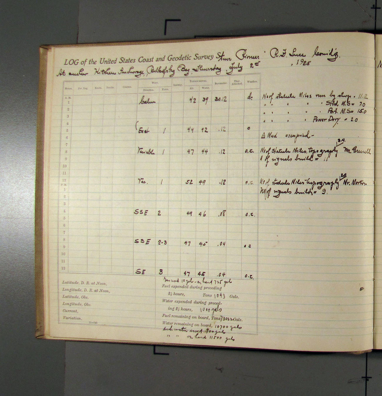
According to the log you should be anchored at Kitchen anchorage at 55.127955, -162.116727
If you go to google maps and enter 55.122132, -162.133486 you will see a fisherman setting his/her nets.
A couple of days later she references "Blink", "Saw" & "Stag" without identifying the type. I assume they are either triangulations or signals. The angles between them are used to specify an anchorage position. These may be on Fox Island.

King cove is just round the corner to the West
55.04467, -162.31832
Stag Point.
N 54°59′00″ W 162°18′00″
Hope this helps.
No help with the rest of trig points.
Just to brighten up yoour day I found this map.
https://www.davidrumsey.com/luna/servle ... C360786637
Re: Alaskan Place Names -- Discussion
Hello studentforever and Stuart!
I've located four of the five mentioned stations and got a candidate for the fifth one.
Unfortunately there are both Doc and Doe triangulation stations on Deer Island, but the Doe one is on the southwestern coast, shortly north of Bent Cape, so Doc is definitely the one we're looking for.

Here's geonames links and coordinates:
Doc 54.91365, -162.23609
Mud 54.95499, -162.23602
Stag 54.98319, -162.32419
Saw 54.96546, -162.3692
Regarding Blink... looking at angles (Stag -101.5, Saw, Blink +41.6 - i hate this notation, it's always terrible to work out places this way) Blink is possibly the actual light (which was flashing already in 1925), i've added Blink as an alternate in our database as our best guess
Fox Island Light 54.95516, -162.43359
On the same little Fox Island there's also the actual "Fox 2" triangulation station on top of the hill... since the angles notation it can be a candidate as well, but I'd probably go with blink being the light.


 the amount of details there is astonishing
I've located four of the five mentioned stations and got a candidate for the fifth one.
Unfortunately there are both Doc and Doe triangulation stations on Deer Island, but the Doe one is on the southwestern coast, shortly north of Bent Cape, so Doc is definitely the one we're looking for.
Here's geonames links and coordinates:
Doc 54.91365, -162.23609
Mud 54.95499, -162.23602
Stag 54.98319, -162.32419
Saw 54.96546, -162.3692
Regarding Blink... looking at angles (Stag -101.5, Saw, Blink +41.6 - i hate this notation, it's always terrible to work out places this way) Blink is possibly the actual light (which was flashing already in 1925), i've added Blink as an alternate in our database as our best guess
Fox Island Light 54.95516, -162.43359
On the same little Fox Island there's also the actual "Fox 2" triangulation station on top of the hill... since the angles notation it can be a candidate as well, but I'd probably go with blink being the light.
Just to brighten up yoour day I found this map.
https://www.davidrumsey.com/luna/servle ... C360786637
-
studentforever
- Posts: 682
- Joined: Sun Jul 05, 2020 9:23 am
Re: Alaskan Place Names -- Discussion
Thank you very much, that makes a lot more sense of the entries. The explanation for "Blink" definitely makes sense and is one that didn't occur to me.
That map is amazing - someone has a warped sense of humour. I think that should be put somewhere else on the forum where it is more likely to be seen by other editors and even visitors. I'm not sure where, possibly one of the chat sections, but do put it out because other users will never find it and it is a gem.
That map is amazing - someone has a warped sense of humour. I think that should be put somewhere else on the forum where it is more likely to be seen by other editors and even visitors. I'm not sure where, possibly one of the chat sections, but do put it out because other users will never find it and it is a gem.
Re: Alaskan Place Names -- Discussion
I just added it to the Alaska reference thread
-
studentforever
- Posts: 682
- Joined: Sun Jul 05, 2020 9:23 am
Re: Alaskan Place Names -- Discussion
Pioneer has also referred to Wolfe Point as she left Port Moller. Why a point should be labelled 'historical' when there is no alternative name I do not know but such is life.
https://www.geonames.org/5878301/wolf-p ... rical.html
She then refers to Fawn Point
https://www.geonames.org/5861998/fawn-point.html
https://catalog.archives.gov/id/247055502?objectPage=81
https://www.geonames.org/5878301/wolf-p ... rical.html
She then refers to Fawn Point
https://www.geonames.org/5861998/fawn-point.html
https://catalog.archives.gov/id/247055502?objectPage=81
Re: Alaskan Place Names -- Discussion
I think it's because Wolf Point is less and less an existing point... the island on which it was is practically submerged, not sure it's still a current addressable feature. I've fixed on geonames though, as on the very last usgs map (2020) the eastern extremity of the former Walrus Island the point is still named as such.
Walrus Island itself is no more named on that same map, and is just a narrow sand bank which changes constantly (compare google satellite imagery with bing maps or wikimapia one and noaa historical charts) in that case i think the "historical" addition is correct, no modern map is mentioning it as such anymore.
The dealing of geonames with old things that exist no more has always been a little ambiguous. When adding alternate names there's a specific checkbox to enter historical ones, but there's no way to add something that does not exist anymore except populated places... so to distinguish from currently existing features, which is the main purpose of geonames, people have resorted to use (historical), I've added several myself. In general it's used to place a marker for something that is no more there.
Added both Wolf Point and Fawn Point to the database. Thanks!
-
studentforever
- Posts: 682
- Joined: Sun Jul 05, 2020 9:23 am
Re: Alaskan Place Names -- Discussion
Ah that makes sense. There are a few historic places on the coast of Britain which are no more - quite a few on the east coast of Yorkshire, for example. Some, especially with church towers, could have been mentioned in 19th century sailing guides. Spurn Point - well cited with lighthouse - will probably be no more by the end of the century. The road to the lighthouse has been closed to ordinary traffic recently, although it can be walked with care and attention to tides and winds, they have a coastal monitoring project in place. Thanks for the info.
-
studentforever
- Posts: 682
- Joined: Sun Jul 05, 2020 9:23 am
Re: Alaskan Place Names -- Discussion
Just noticed that Pioneer refers to a Cape Pankow Light near to False Pass which seems to be Cape Pankof Light. This isn't currently listed as an alternate name in the database.
https://catalog.archives.gov/id/247055502?objectPage=83
https://catalog.archives.gov/id/247055502?objectPage=83
Re: Alaskan Place Names -- Discussion
Just added the new alternate name to database and to geonames. Thanks!
When dealing with Russian names, there's a wide range of transliterations to English... the ending -ov (-ов in cirillic) can become -of, -off, -ow, even in native's last names, maps, books and whatsoever.
The cape was named by Russian explorer Gavril Sarychev... it's another name you may have encountered on Unimak Island, spelt Sarichef (that 'ch' in the middle is another troublesome letter that may become 'tch' as it's the single Russian letter ч) and the name was given after an Aleut chief named Sergey Pan'kov (or Сергей Паньков).
The most funny of these, in my opinion, is however the earliest Alaskan maps where 'Oo' and 'Ou' were used instead of 'U'... with Unalaska being Oonalaska or Ounalaska... you can experience a full immersion of weird names by reading those (Ounalga, Oonga, Ouzinkie, Oonimak)

Re: Alaskan Place Names -- Discussion
And of course, Japan, with Sima, Shima, Jima, saki, zaki etc etc.
-
studentforever
- Posts: 682
- Joined: Sun Jul 05, 2020 9:23 am
Re: Alaskan Place Names -- Discussion
Pioneer really getting obscure this time. She references Cape Kuyuyukak which didn't show on geonames. The main reference I have found is
https://alaska.guide/cape/cape-kuyuyukak
which does include a small map. There are links to other maps but Firefox seems to think the link is a security risk so I came out. Most of them seem to be centred on Sutwik Island.
https://catalog.archives.gov/id/247055502?objectPage=74
A more useful location link would be great.
This might help - further down the page is a reference to Ashiiak Island, not on the data base but
https://www.geonames.org/5879694/ashiiak-island.html
There is also an angle between the two of them which might help someone with better navigation skills to locate the headland on a more detailed map
Re: Alaskan Place Names -- Discussion
The first link has a position listed that, on Google Maps, is exactly on the point. It is also about 16 miles NE of the other Cape Listed.
Converting 56°53'57"N, 156°49'28"W
56.8994439, -156.8247219
I opened one of the other links. My Anti-Virus said that their certificate expired. The map came up when I told my browser to go ahead, but I ddn't look at the map all that closely. The position on the first link was on the point shown.
Converting 56°53'57"N, 156°49'28"W
56.8994439, -156.8247219
I opened one of the other links. My Anti-Virus said that their certificate expired. The map came up when I told my browser to go ahead, but I ddn't look at the map all that closely. The position on the first link was on the point shown.