Pioneer references Lockwood Rock Buoy at 11.45am. I think she means a buoy at Point Lockwood Rock
https://catalog.archives.gov/id/247055403?objectPage=72
https://www.geonames.org/5556432/point- ... -rock.html
Alaskan Place Names -- Discussion
Moderator: Matteo
-
studentforever
- Posts: 682
- Joined: Sun Jul 05, 2020 9:23 am

Re: Alaskan Place Names -- Discussion
Possibly the loogkeeper didn't read Pt on the map... if the map was this one it's pretty probable, i did read Lockwood Rock as well at first glance 
We had the buoy as "Wrangell Narrows Channel Buoy 1" in the db, added an alternate name to it and to geonames as well. The buoy has been converted to a light beacon at some point, and is currently known as the "Wrangell Narrows Channel Light 1".
We had the buoy as "Wrangell Narrows Channel Buoy 1" in the db, added an alternate name to it and to geonames as well. The buoy has been converted to a light beacon at some point, and is currently known as the "Wrangell Narrows Channel Light 1".
-
studentforever
- Posts: 682
- Joined: Sun Jul 05, 2020 9:23 am
Re: Alaskan Place Names -- Discussion
I wondered if it had been renamed as one of that set. I didn't realise that the map/chart might be so easy to mis-read but that would certainly explain the error. I wonder how many people not editing in OW have found the database and downloaded it for their own purposes?
Re: Alaskan Place Names -- Discussion
It really depends on the map... All maps were corrected (usually yearly), but smaller issues as this one tend to carry over for decades... the 1919 map i linked could have been used for years, with the Pt hidden in the sand banks. Someone looking at it in a hurry would easily forget to put the Pt in.
Here's how various map reported the place, 1911 one is probably the best placement but looking at the features either some major erosion happened or the map wasn't too precise. Since at least 1919 someone decided to stick the Pt near the shoreline and there it apparently remained in all following nautical maps (haven't checked what happened after 1947). In 1931 and 1947 maps the buoy had already became a light.
Maps here are of course from NOAA historical map search (https://historicalcharts.noaa.gov/search.php), for the US there's simply nothing comparable

As for the db, I've put links all around the Geographical Help Board (in the files section of the OWTools website there are dumps of the db in reference-thread-like-list, csv, kml and google maps format, all updated immediately as soon as the place is saved in the database)... hope people interested in the geography of the places our ships are cruising in find them, for me is a fundamental aspect - the 'where' goes always along with the 'when' and 'how' when i read anything historical
Here's how various map reported the place, 1911 one is probably the best placement but looking at the features either some major erosion happened or the map wasn't too precise. Since at least 1919 someone decided to stick the Pt near the shoreline and there it apparently remained in all following nautical maps (haven't checked what happened after 1947). In 1931 and 1947 maps the buoy had already became a light.
Maps here are of course from NOAA historical map search (https://historicalcharts.noaa.gov/search.php), for the US there's simply nothing comparable
As for the db, I've put links all around the Geographical Help Board (in the files section of the OWTools website there are dumps of the db in reference-thread-like-list, csv, kml and google maps format, all updated immediately as soon as the place is saved in the database)... hope people interested in the geography of the places our ships are cruising in find them, for me is a fundamental aspect - the 'where' goes always along with the 'when' and 'how' when i read anything historical
-
studentforever
- Posts: 682
- Joined: Sun Jul 05, 2020 9:23 am
Re: Alaskan Place Names -- Discussion
Yes, you can see how it might get lost in the background detail.
I don't think I'm quite as anxious as you to have a detailed mental image of a journey but I do get cross if I have to spend ages hunting for such an image when the writer assumes I already have the image and the writing only makes sense if you can visualise the layout but then gives me no help to generate layout if I don't know the area being written about. I can use the Lat and Long as graph coordinates to give me a sense of how the ship is moving even though I have no idea of the terrain connecting the points which is why I like to track down the locations which the log keeper has cited. I do get a sense of satisfaction when I've got them all pinned down even though I need to use the skills of people like you for the trickier log entries. Thanks again
I don't think I'm quite as anxious as you to have a detailed mental image of a journey but I do get cross if I have to spend ages hunting for such an image when the writer assumes I already have the image and the writing only makes sense if you can visualise the layout but then gives me no help to generate layout if I don't know the area being written about. I can use the Lat and Long as graph coordinates to give me a sense of how the ship is moving even though I have no idea of the terrain connecting the points which is why I like to track down the locations which the log keeper has cited. I do get a sense of satisfaction when I've got them all pinned down even though I need to use the skills of people like you for the trickier log entries. Thanks again
Re: Alaskan Place Names -- Discussion
Thank YOU for contributing so much to the Geographical Help Board!
Putting all pieces together and filling the gaps is a big part of the fun
Putting all pieces together and filling the gaps is a big part of the fun
-
studentforever
- Posts: 682
- Joined: Sun Jul 05, 2020 9:23 am
Re: Alaskan Place Names -- Discussion
There is also a light on Fox Island (1)
https://www.geonames.org/12175985/fox-island-light.html
https://www.geonames.org/12175985/fox-island-light.html
-
studentforever
- Posts: 682
- Joined: Sun Jul 05, 2020 9:23 am
Re: Alaskan Place Names -- Discussion
Pioneer refers to a 'Low Point' near to Lenard Harbor. I think it might be an alternate name for Kaslokan Point
https://www.geonames.org/5865909/kaslokan-point.html
https://www.geonames.org/5865909/kaslokan-point.html
Re: Alaskan Place Names -- Discussion
That's pretty interesting... the Cold Bay was pretty uncharted up to at least 1917 (1912 map, 1917 map) and was fully surveyed in this 1925 map. The point is already named Kaslokan in 1925.
I'm still trying to find out something in between 1917 and 1925, Kaslokan Point would indeed seem to be a nice candidate for a "Low Point" in the bay... could you link the logpage? Maybe I could try to cross check other positions, courses and bearings to be sure.
Edit: It seems Low Point is an alternate for Kaslokan Point in genoames, which makes your guess 99% right... i'm trying to dig out where that information came from, it's possibly in one of the Alaska Dictionaries
Edit (2): Found it in the The Dictionary of Alaska Place Names by Donald J Orth. Despite the book is from 1967, it's far enough evidence to make it indeed the one you guessed.
Just added Kaslokan and Low Point to the database. Thanks!
-
studentforever
- Posts: 682
- Joined: Sun Jul 05, 2020 9:23 am
Re: Alaskan Place Names -- Discussion
I now work to find a new site referenced in the log but not the database by bringing up a nearby sight/site on geonames, reducing the mag and then searching. That brought up Low Point but the Kaslokan map. Hence the the entry here! I will admit that I don't then hunt for the primary reference - I just send it to you via the website. I'm impressed by your thoroughness but I'm not sure if I have your dedication. I will try a few other stategies if that method doesn't work but I find reading detailed maps on my computer a bit challenging so the amount of effort on them is limited by my current level of frustration.
Re: Alaskan Place Names -- Discussion
Hey no worries for that! The name on the log and an a geonames link are more than enough! I'm always keen on digging up further info and pinpointing the place before adding to the database
I Always double check to keep our info are accurate to our best effort... and nine times on ten geonames has it right already, usually all i need to do is only adjust place position (depending on the area there can be slight to severe errors).
This place in particular was quite peculiar as the bay wasn't surveyed before and the point was named Kaslokan in a 1925 map (not sure but i guess you're still editing 1925), so there was a little chance for this to be one of those places initially named as X in the first rough surveys, and then renamed Y shortly afterwards (I'm still wondering if it is, but the confirmation on Alaska Dictionary is enough, won't dig further )... these are often terribly tricky to find unless we have precise bearings in the logs.
I Always double check to keep our info are accurate to our best effort... and nine times on ten geonames has it right already, usually all i need to do is only adjust place position (depending on the area there can be slight to severe errors).
This place in particular was quite peculiar as the bay wasn't surveyed before and the point was named Kaslokan in a 1925 map (not sure but i guess you're still editing 1925), so there was a little chance for this to be one of those places initially named as X in the first rough surveys, and then renamed Y shortly afterwards (I'm still wondering if it is, but the confirmation on Alaska Dictionary is enough, won't dig further
-
studentforever
- Posts: 682
- Joined: Sun Jul 05, 2020 9:23 am
Re: Alaskan Place Names -- Discussion
If you really want to dig then Pioneer's field records include lots of triangulation points, named but not geolocated on the deck logs, however they are probably better located on their topographic logs which I understand are on file somewhere or other in the US. They also have stations named and indicated by a circle with a dot in the centre instead of the triangle for triangulation points. How easy they are to find I don't know but they are probably in the original coastal survey data. Pioneer often cites anchorage points by reference to these named sites, sometimes even overnight moorings although it isn't much help for me just editing logs. I suspect that Pioneer's data form the basis of the 1925 maps. Most of these come from summer 1924 which would be sent off to HQ in the autumn. I am going through the logs removing highlights where possible before a final check through and sending the logs off to Caro for her skilful touch.
Re: Alaskan Place Names -- Discussion
Triangulation Points are usually found in all USGS maps post WW2 (you can find all of them in USGS Topoview). The good thing is they're very rarely moved around once they're placed, so they can be used, with a grain of salt of course, even when dealing with older logs. I think we've placed a few in the database.
I'm pretty curious... i think i'll definitely have to peek at Pioneer edited logs
I'm pretty curious... i think i'll definitely have to peek at Pioneer edited logs
-
studentforever
- Posts: 682
- Joined: Sun Jul 05, 2020 9:23 am
Re: Alaskan Place Names -- Discussion
Don't hold your breath over the finished log - another jag courtesy of the NHS and the brain fog will set in again!
However, Pioneer anchors off triangulation "Low" and later in Traders Cove.
The latter is near to Traders Head but is at Lat 54.91, Long -162.31
https://www.geonames.org/5876527/traders-cove.html
I tried your tip for finding triangulation "Low" but no luck with your map source - whether me or it I don't know.
Re: Alaskan Place Names -- Discussion
I'm in no rush
Not your fault for the Low triangulation point... it must have been removed at some point. USGS maps of the area are not great, and triangulation points are shown only on 1989-1995 maps (and have been removed, probably because they're anachronistic now that we have gps, from 2020 maps).
On the 1995 maps we can read names of several triangulation points (Vin, Shoal, Not, Easy, Bay, Bed, New, Trader) but unfortunately not Low... i've not checked outside the Chevin Bay area, not sure if Pioneer reported it before entering the bay (nor if she entered it from south or north. i'd guess from Isanotski Strait as the northern area was still quite uncharted in 1927) or if she anchored near it inside Traders Cove:
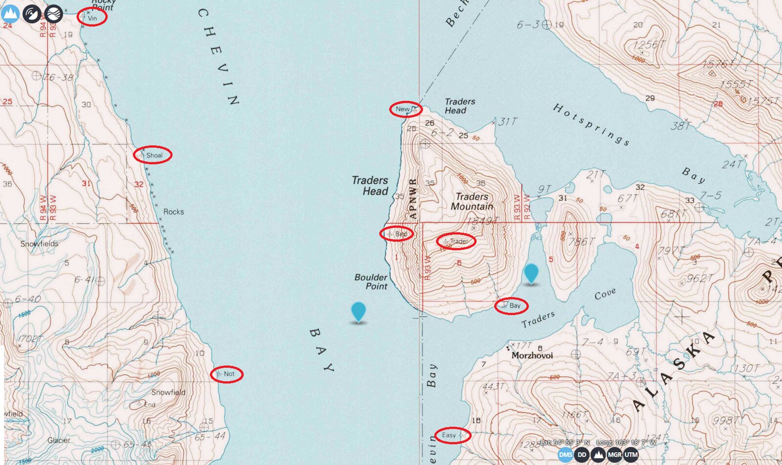
-
studentforever
- Posts: 682
- Joined: Sun Jul 05, 2020 9:23 am
Re: Alaskan Place Names -- Discussion
Ah, that makes sense, I was using the wrong dates. However just in case you want to do more delving here are some links to relevant pages
https://catalog.archives.gov/id/247055403?objectPage=29
https://catalog.archives.gov/id/247055403?objectPage=28
https://catalog.archives.gov/id/247055403?objectPage=27
https://catalog.archives.gov/id/247055403?objectPage=29
https://catalog.archives.gov/id/247055403?objectPage=28
https://catalog.archives.gov/id/247055403?objectPage=27
Re: Alaskan Place Names -- Discussion
Oh that makes more sense... from the very first page we know they're anchored in Thinpoint (or Thin Point) Cove (54.97833, -162.65252), about 50 km east of False Pass, Isanotski Strait and Traders Cove, when they reference Low triangulation point.
And the point is in fact still there on the western point of the bay (1963 map on Topoview, right to left we have Low, Chil and Kelp), i've just added it to geonames (position of the triangulation point 54.96107, -162.70699):

They also mention triangulation point Chil both in June 4 and June 6 pages, which is visible on same 1963 map, shortly southwest of Low (added to geonames, position 54.93502, -162.77691)
I cant seem to find triangulation point Wale, which they rebuilt, mainly because it's in the weather page and its not too clear when they worked on it... i'm trying to locate it, if i have any luck i'll edit this post
And the point is in fact still there on the western point of the bay (1963 map on Topoview, right to left we have Low, Chil and Kelp), i've just added it to geonames (position of the triangulation point 54.96107, -162.70699):
They also mention triangulation point Chil both in June 4 and June 6 pages, which is visible on same 1963 map, shortly southwest of Low (added to geonames, position 54.93502, -162.77691)
I cant seem to find triangulation point Wale, which they rebuilt, mainly because it's in the weather page and its not too clear when they worked on it... i'm trying to locate it, if i have any luck i'll edit this post
-
studentforever
- Posts: 682
- Joined: Sun Jul 05, 2020 9:23 am
Re: Alaskan Place Names -- Discussion
That's great. I'll add those to the footnotes in the log. There are quite a few more references to triangulations and signals, I was particularly anxious to track "Low" because she anchored off it for the night. However, if you are feeling really keen there are a several more referenced earlier. Let me know if you would like them. I don't know if any more ships will be in that area and we will get the logs for them. I don't think we have many of the survey ships in our dataset yet.
Re: Alaskan Place Names -- Discussion
Yeah, its not so likely other ships will ever address them... use your own judgement, nothing is mandatory and place names have precedence over triangulation points, beacons and buoys, i don't mind working them out if needed, and adding them to geonames and our database once we find them.
The Low was a more relevant one since the ship was anchored nearby, other ones could be less meaningful... for our database collection the more the better, but don't let this hinder you anyhow, the editing job has precedence.
The Low was a more relevant one since the ship was anchored nearby, other ones could be less meaningful... for our database collection the more the better, but don't let this hinder you anyhow, the editing job has precedence.
-
studentforever
- Posts: 682
- Joined: Sun Jul 05, 2020 9:23 am
Re: Alaskan Place Names -- Discussion
Thanks Matteo. That was my feeling. If the triangulation point gives significant information on her course then it would be good to locate it, similarly if some incident occurs at the site (accident for example) we also would like to locate it, otherwise don't put in much effort. Of course if another triangulation point turns up on the same map we might as well add it.