Weather history miscellany

Re: Weather history miscellany
MODIS Image of the day

Korean Peninsula(10/2/2026)
Suspended sediment floated off the western coast of the Korean Peninsula on October 2, 2026, when the Moderate Resolution Imaging Spectroradiometer (MODIS) on NASA’s Aqua satellite acquired this true-color image of the region. Sediment, which looks muddy tan when it floats near the surface and green as it sinks, appears thickest in the Yellow Sea, especially off the coast of South Korea.
Re: Weather history miscellany
MODIS Image of the day

Fires in Oregon(9/30/2026)
Oregon’s 2026 wildfire season has been a record one, with more than 2.1 million acres burned as of late September 2026. Idaho’s Business Review reports that suppression costs had hit 1.4 billion dollars. Most fires were east of the Cascades and fire crews worked diligently to prevent or minimize destruction from the fires.
Fires were still burning in Oregon east of the Cascades on September 30, 2026, when the Moderate Resolution Imaging Spectroradiometer (MODIS) on NASA’s Aqua satellite acquired this true-color image. Each red “hot spot” marks an actively burning fire. Gray plumes of smoke blow generally towards the east from most of the hot spots, evidence of the strong, gusting wind that causes fire to spread.
Re: Weather history miscellany
NASA Earth Observatory
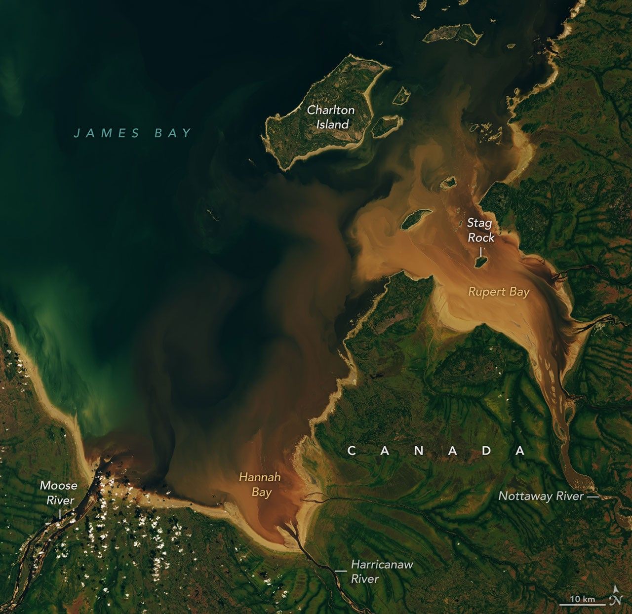
The Beaver Brown Waters of Rupert BaySeptember 27, 2026
The Cree word pahtaaunaakun seems particularly apt for describing the distinctive brown hues of the waters that drain into Hannah Bay and Rupert Bay in Canada. Meaning the "color of singed beaver" in Southern East Cree, the word evokes the rich brown of the humic-substance-stained waters that were flowing into the two bays in late September 2026, as well as the role that beavers have long played in the mythology and history of the region.
The mudflats, the light brown areas along the shore, are a product of the shallow, sloping bathymetry in the southernmost part of James Bay. Postglacial rebound is slowly lifting the entire landscape, and rivers continually deposit fine mud particles and other sediments that build up the flats. The comings and goings of tides and river currents often stir up the mud, producing the lighter brown plumes of suspended sediment that mix with the incoming river water.As the rivers and streams that flow into the two bays—the southernmost extensions of James Bay—wind through the boreal forests and boggy wetlands of northern Quebec and Ontario, they often carry water stained brown by colored dissolved organic matter (CDOM), which absorbs light in the blue and ultraviolet parts of the electromagnetic spectrum and causes water to appear brown. CDOM, including organic substances derived from tannins and lignins, leaches from decaying leaves, roots, bark, and soils into streams and rivers. Similar substances are what stain tea water brown.
Differences in moisture levels and vegetation patterns likely contribute to the green dendritic, veinlike patterns visible onshore. Denser, more forested growth along stream channels appears dark green, while the poorly drained landscapes in the surrounding peat bogs have less extensive tree cover and appear lighter green.
Re: Weather history miscellany
NASA Earth Observatory
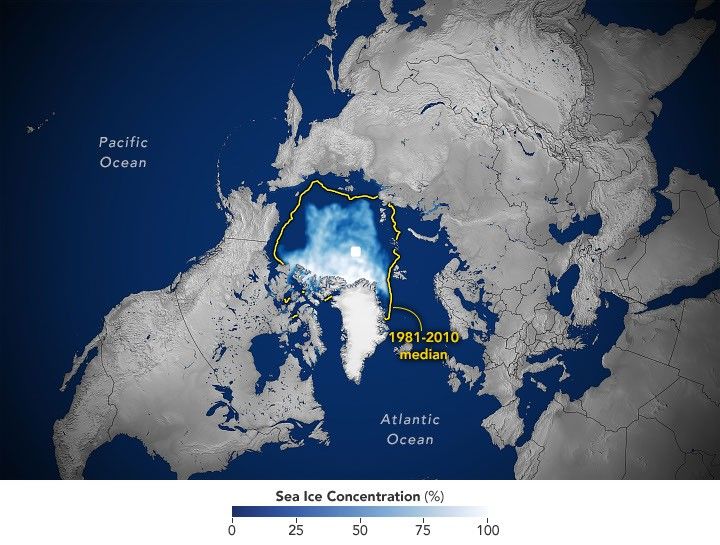
Arctic Sea Ice Shrinks to Its 2026 Minimum
Arctic sea ice reaches its annual minimum extent on September 12, 2026, tying several past years for the 10th-lowest minimum in the satellite record.
Arctic Sea Ice Shrinks to Its 2026 Minimum
Arctic sea ice reaches its annual minimum extent on September 12, 2026, tying several past years for the 10th-lowest minimum in the satellite record.
Re: Weather history miscellany
NASA Earth Observatory
Fighting Drought in Texas Cotton Country
For many longtime cotton farmers in the Texas High Plains, the 2026 drought sparked flashbacks to catastrophic harvests of the past. Miserably dry seasons forced farmers in America's largest cotton-producing region to abandon massive portions of their dryland crop, including 72 percent in 2022 and 66 percent in 2011.
But in some ways, farmers felt the drought in 2026 entered new territory. "This is the first year that we've had cotton completely die," said Lacy Cotter-Vardeman, a farmer based in Lubbock County whose family has worked the land there for several generations. "I was just talking to our insurance people, and they said they'd never seen this before," she said, adding that roughly 90 percent of her dryland cotton was dead.
 September 22, 2025 |
 September 9, 2026 |
For many longtime cotton farmers in the Texas High Plains, the 2026 drought sparked flashbacks to catastrophic harvests of the past. Miserably dry seasons forced farmers in America's largest cotton-producing region to abandon massive portions of their dryland crop, including 72 percent in 2022 and 66 percent in 2011.
But in some ways, farmers felt the drought in 2026 entered new territory. "This is the first year that we've had cotton completely die," said Lacy Cotter-Vardeman, a farmer based in Lubbock County whose family has worked the land there for several generations. "I was just talking to our insurance people, and they said they'd never seen this before," she said, adding that roughly 90 percent of her dryland cotton was dead.